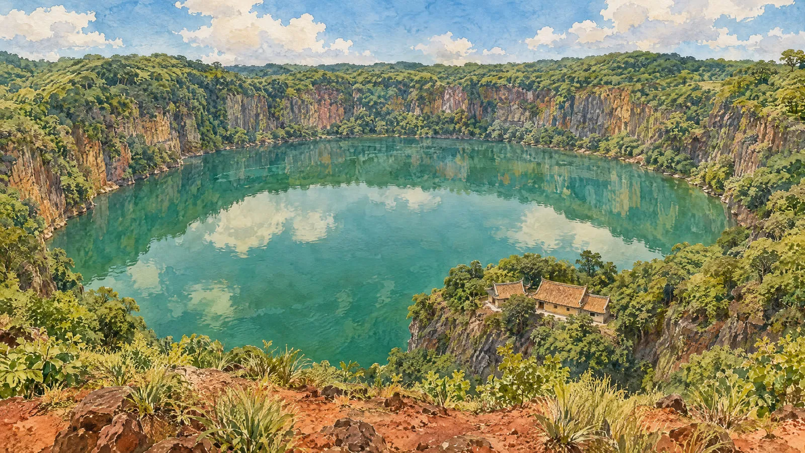
Huguangyan, 湖光岩, is a lake inside the crater of an old volcano. It lies in Huguang town, 湖光镇, in the Mazhang District of Zhanjiang, on the Leizhou Peninsula in Guangdong. A crater is the bowl-shaped hole an eruption leaves behind. This one was not built up into a cone. It was blasted open by steam, and the bowl later filled with water. A crater made that way is called a maar, so the lake also goes by Huguangyan Maar Lake. It formed about 140,000 to 200,000 years ago. Today it is one of the most prominent places in the Leiqiong UNESCO Global Geopark, a protected volcanic area on both sides of the sea between the peninsula and Hainan.
Maybe you met the name on a list of Zhanjiang sights while planning the family’s first trip back, and you want to know if it earns half a day. Let us walk up to the rim and look. There is a hole made by steam, an old temple on its cliffs, a Song dynasty name cut into the rock, and a bed of mud that scientists from two countries have read like a diary. The Leizhou Peninsula: red soil, old volcanoes and the strait tells the story of the whole volcanic land. This page stands at one rim of it.
How did a volcano make Huguangyan Lake?
When we picture a volcano, we picture a hill. Huguangyan is the other kind: a hole.
Chinese Wikipedia, the Chinese-language edition of the online encyclopaedia, sets out how it happened. Deep down, magma was rising. Magma is rock so hot it has melted. Underground water, or water from the surface, met that magma head on. The water turned to steam in an instant, and the steam exploded with enormous force. The broken rock it threw up fell back around the blast and piled into a ring. Inside the ring was a hollow, and over a long time the hollow filled with water and became a lake.
So the high ground around Huguangyan is not a volcano’s peak. It is the ring of rubble around the hole, the rim you stand on to look down at the water. The same encyclopaedia dates the blast to about 140,000 to 200,000 years ago. Nobody was there to write it down.
What is the lake like at the rim?
Picture a round bowl of water about two kilometres across, with steep walls all the way round. Cliffs close the lake in on all four sides. That shape gave it an old name, Huyang Rock, 湖阳岩. The name comes from a phrase, fu yin er bao yang (负阴而抱阳), about a place with shade at its back and sun in its arms. Its water is so clear and still that people also call it Mirror Lake, 镜湖. China Daily, an English-language newspaper from China, describes the same scene in a 2017 page about the park: volcanic slopes, cliffs and crags all round, and water like a mirror that throws back the rocks.
Read the three characters of the name one at a time and you have the place in small. Hu (湖) is lake, guang (光) is light, and yan (岩) is rock or cliff.
How big and how deep is it? Two accounts give figures, and on depth they are far apart. One is Chinese Wikipedia. The other is a 2019 article posted on The Paper, a Chinese news site, by the Beibu Gulf Research Centre. The Beibu Gulf is the sea off the west coast of the peninsula. Here they are side by side.
| What | Chinese Wikipedia | Beibu Gulf Research Centre, 2019 |
|---|---|---|
| Area of water in the crater | about 2.23 square kilometres | not given |
| Longest, east to west | 2 kilometres | not given |
| Widest, north to south | 1.8 kilometres | not given |
| Water it holds | about 25 million cubic metres | not given |
| Average depth | about 14.5 metres | 22 metres |
| Deepest point | 23 metres | 48 metres |
| One walk round the lake | not given | 7 kilometres |
| Core of the protected area | 4.7 square kilometres | not given |
On how deep the lake is, the two are far apart, and we cannot settle it from here.
Who named Huguangyan, and who built on its cliffs?
People came to this lake long before scientists did, and they built on its walls.
What the record shows. The oldest building here is Lengyan Temple, 楞严寺, a Buddhist temple. UNESCO, the United Nations body for education, science and culture, dates it to the Sui dynasty, which ruled China from 581 to 618. A dynasty is one family line of emperors. China Daily’s page says the same: in the Sui dynasty, Buddhist monks built temples here, Lengyan Temple and the Baiyi Nunnery among them. A nunnery is a temple where Buddhist nuns live. The 2019 article places Lengyan Temple by the water, built on a volcanic cliff that looks out over the lake.
China Daily’s page also says this. The three characters Huguangyan (湖光岩) on the cliff were written by Li Gang, 李纲, a chancellor of the Song dynasty, and the inscription is still there, whole. A chancellor was the emperor’s chief minister. An inscription is writing cut into stone. That page is a China Daily feature carried on a government website, and it states the inscription as fact.
Li Gang is not a stranger on this site. He lived from 1083 to 1140. He became Grand Chancellor in 1127, the year the Jin invasion ended the Northern Song, and he argued for fighting back. He was pushed out of office and in the end sent south in exile. He is one of the Ten Worthies of Leizhou, the Song statesmen exiled to the far south, who are honoured together in one shrine.
What tradition adds. The 2019 article tells how it happened. One day Li Gang sat on the cliff with Shi Cong, 释琮, the head monk of the temple. They drank wine and talked, and Li Gang wrote out the three large characters. That, says the article, is how Huguangyan got its name. It places the carving on the rock face above the temple’s main hall, half hidden in the grass, and calls it his own hand. It is a lovely scene. The article gives no date for it and names no older book it comes from.
What we do not know yet. When Li Gang wrote it. The China Daily page and the 2019 article both give him the characters, and neither gives a year. Chinese Wikipedia’s page on the lake does not mention him at all. And the old name, Huyang Rock, raises a question we cannot answer: did Li Gang give the lake a new name, or write down one that was already in use?
What does the lake mud remember?
Here is the part of Huguangyan that reaches furthest, and it lies at the bottom of the water.
Mud settles on the floor of this lake, and it keeps a record of the climate and the land around it. The 2019 article says why the record is a good one: the ring of hills cuts the lake off from surface water outside, so what settles is a true record. UNESCO says Huguangyan is where the first Chinese research on maar lakes was done. It says the lake is still an important place for scientists of different countries to work together, especially Chinese and German scientists. The Global Geoparks Network, the network that UNESCO’s geoparks belong to, says the same thing in its own words.
How far back does the mud go? China Daily’s page says the lake bed has seen 100,000 years of changes in climate and environment, and that experts call it “the Almanac of Natural Environmental Changes”. An almanac is a yearly book of weather and seasons. The 2019 article says 160,000 years. These are the reach of the whole record, as each account tells it.
One study shows what the record can do. In January 2007 the science journal Nature published a paper on Huguangyan’s mud. Seven of its ten authors worked at the GeoForschungsZentrum, a German earth-science research centre in Potsdam. One worked at the Chinese Academy of Sciences in Beijing, and two at universities in the United States. They measured the last 16,000 years of the mud, using its magnetism and the titanium in it, to work out how hard the winter monsoon blew. A monsoon is the big seasonal wind of Asia. They found stretches when the winter winds were strong just when cave records suggest the summer rains were weak.
Then the authors made a bold suggestion, and they called it a suggestion. The shifting tropical rain belt, they wrote, could have helped bring down both the Tang dynasty in China and the Classic Maya in Central America. That is the same Tang dynasty that renamed this land Leizhou in 634. So the mud under a lake on the peninsula may hold a clue to the fall of the dynasty that gave the peninsula its name. “May” is the right word. The paper offers it as a possibility, not a proof.
Is Huguangyan part of the Leiqiong UNESCO Global Geopark?
Yes. Huguangyan is part of the Leiqiong UNESCO Global Geopark, 雷琼世界地质公园, and UNESCO names Huguangyan Maar Lake among the geopark’s most prominent features.
A geopark is an area UNESCO recognises and protects for its geology, the way a heritage site is protected for its history. Read the name slowly. Lei (雷) stands for Leizhou and Qiong (琼) for Hainan. The geopark straddles the Qiongzhou Strait, the narrow sea between them. It spans the city of Zhanjiang on the mainland and the city of Haikou on the island, about 3,050 square kilometres in all.
Why does one park cross the sea? Because the rock does. UNESCO describes the whole area as one volcanic belt, the Leiqiong Rift Volcanic Belt. A rift is a long crack where the earth’s crust is being pulled apart. UNESCO counts more than 100 volcanoes across the geopark, with 38 protected volcanic structures among them. It counts 78 geosites, the single spots chosen for their geology. The Global Geoparks Network’s page gives 75. Huguangyan is on the northern shore. Near Haikou on the southern shore, at Mount Ma’an, paths lead walkers past lava flows and volcanic cones.
So a family from the peninsula and a family from Hainan stand on the same volcanic ground, split by a strait. The peninsula page follows how that sea came between them.
Two years come up for when the geopark was named, and both are right. The Global Geoparks Network says Leiqiong applied in 2005 and was accepted in 2006. Its title was checked again in 2010, 2014 and 2018, and Chinese Wikipedia gives 2023 as the latest check. UNESCO’s own page gives 2015. That is the year UNESCO’s member countries made “UNESCO Global Geopark” the official title for the network’s members. So 2006 is when Leiqiong joined, and 2015 is when the joining took UNESCO’s name.
One big claim you may meet should be read with care. A page on the Guangdong local chronicles office’s website calls Huguangyan “the largest and best-preserved flat-land volcanic lake in the whole world”. The local chronicles office is the government office that keeps the province’s official local histories. UNESCO’s page and the Global Geoparks Network’s page praise the geopark’s volcanoes highly, but neither calls the lake the world’s largest. Treat it as the local government’s pride in its lake, not as a measured fact.
How do you get to Huguangyan from Zhanjiang?
By road, from the city. The scenic area’s address is Huguang town in Mazhang District.
China Daily’s 2017 page puts it 18 kilometres northeast of downtown Zhanjiang. The 2019 article puts it 18 kilometres southwest of the city. The distance matches and the direction does not, so check a map on the day.
Fares, opening hours and bus routes change. They are not given here, so check them close to your trip. By China Daily’s 2017 list, the park has a Volcanic Museum and a Sea Watching Tower as well as the lake and Lengyan Temple, and visitors walk, cycle and have barbecues there. It was named a national 4A tourist attraction in 2003, a grade China gives to its tourist sites.
Getting to Zhanjiang from Malaysia is the bigger step. There is no direct flight. The usual way is to fly to Guangzhou or Shenzhen and take the high-speed train to Zhanjiang. Visiting Leizhou from Malaysia walks through the routes, the papers and the rest of the trip.
So is it worth half a day? We think so, if your family came from anywhere on the peninsula. The red soil of the peninsula is volcanic rock, worn down over a very long time. Most of the time you see that only as red dust on the road. At Huguangyan you can stand on the rim of one of those volcanoes, look down into it, and see the ground of the homeland from the inside. It is close to the city, so it fits beside a village visit rather than taking its place.
What we do not know yet
Four questions stay open.
When Li Gang wrote the name. Two accounts give him the three characters. Neither gives a year, and the older name, Huyang Rock, leaves open whether he chose the name or wrote down one already in use. We do not know yet.
How deep the lake is. Chinese Wikipedia says about 14.5 metres on average and 23 at the deepest. The 2019 article says 22 and 48. One of them is far off, and we cannot tell which.
Which way to drive. Northeast or southwest of downtown? The two accounts that give the 18 kilometres disagree.
What your family called it. If your grandparents had their own name or story for this lake, it may be one that no book holds.
Huguangyan is one stop. The visit is the next chapter: read Visiting Leizhou from Malaysia for how to get from Malaysia to Zhanjiang and on to the family’s village. And if your family is Lui Chew, the older Malayan spelling of Leizhou, and you have stood on this rim, we would love to hear your story, or to take a correction to anything on this page.